


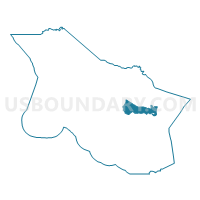
Voting District 10045, Marin County, California
About
Outline

Summary
| Unique Area Identifier | 534801 |
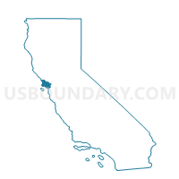
| Name | Voting District 10045 |
| County | Marin County |
| State | California |
| Area (square miles) | 13.98 |
| Land Area (square miles) | 13.97 |
| Water Area (square miles) | 0.01 |
| % of Land Area | 99.94 |
| % of Water Area | 0.06 |
| Latitude of the Internal Point | 38.03790370 |
| Longtitude of the Internal Point | -122.57327700 |
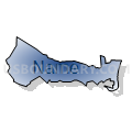
Maps

Graphs
Select a template below for downloading or customizing gragh for Voting District 10045, Marin County, California


Neighbors
Neighoring Voting District (by Name) Neighboring Voting District on the Map
- Voting District 10005, Marin County, CA
- Voting District 10015, Marin County, CA
- Voting District 10050, Marin County, CA
- Voting District 20140, Marin County, CA
- Voting District 40345, Marin County, CA
- Voting District 40346, Marin County, CA
- Voting District 40356, Marin County, CA
- Voting District 50370, Marin County, CA
- Voting District 50400, Marin County, CA
- Voting District BAY, Marin County, CA
Top 10 Neighboring County Subdivision (by Population) Neighboring County Subdivision on the Map
- San Rafael CCD, Marin County, CA (70,235)
- Ross Valley CCD, Marin County, CA (58,738)
- Novato CCD, Marin County, CA (58,652)
- Northwest Marin CCD, Marin County, CA (8,656)
Top 10 Neighboring Place (by Population) Neighboring Place on the Map
- San Rafael city, CA (57,713)
- Novato city, CA (51,904)
- Lucas Valley-Marinwood CDP, CA (6,094)
- Santa Venetia CDP, CA (4,292)
- Sleepy Hollow CDP, CA (2,384)
Top 10 Neighboring Elementary School District (by Population) Neighboring Elementary School District on the Map
- San Rafael City Elementary School District, CA (54,884)
- Ross Valley Elementary School District, CA (23,470)
- Dixie Elementary School District, CA (21,296)
- Lagunitas Elementary School District, CA (3,652)
- Nicasio Elementary School District, CA (704)
Top 10 Neighboring Secondary School District (by Population) Neighboring Secondary School District on the Map
- Tamalpais Union High School District, CA (113,295)
- San Rafael City High School District, CA (76,180)
Top 10 Neighboring Unified School District (by Population) Neighboring Unified School District on the Map
Top 10 Neighboring State Legislative District Lower Chamber (by Population) Neighboring State Legislative District Lower Chamber on the Map
Top 10 Neighboring State Legislative District Upper Chamber (by Population) Neighboring State Legislative District Upper Chamber on the Map
Top 10 Neighboring 111th Congressional District (by Population) Neighboring 111th Congressional District on the Map
Top 10 Neighboring Census Tract (by Population) Neighboring Census Tract on the Map
- Census Tract 1150, Marin County, CA (7,249)
- Census Tract 1050, Marin County, CA (6,590)
- Census Tract 1081, Marin County, CA (6,406)
- Census Tract 1070, Marin County, CA (6,142)
- Census Tract 1042, Marin County, CA (5,722)
- Census Tract 1060.02, Marin County, CA (5,625)
- Census Tract 1060.01, Marin County, CA (4,048)
- Census Tract 1130, Marin County, CA (3,656)
- Census Tract 1330, Marin County, CA (3,226)
- Census Tract 1043, Marin County, CA (1,530)
Top 10 Neighboring 5-Digit ZIP Code Tabulation Area (by Population) Neighboring 5-Digit ZIP Code Tabulation Area on the Map
- 94901, CA (41,157)
- 94903, CA (29,040)
- 94949, CA (17,202)
- 94960, CA (15,740)
- 94973, CA (1,429)
- 94946, CA (699)